Reconstructing Belfast After Terror
Abstract: The article deals with after-war reconstruction in Belfast and offers to study two recent development plans: the 2011 RISE piece of art and the 2012 Titanic Quarter, both of which convey cosmopolitan values and aim at enhancing peace efforts. But what is the level of connectivity provided by such places? In other words, do they contribute to re-stitching the fragmented city? This will lead us to cross-examine the traditional description of spatial divisions in Belfast.
Keywords: Public policy, Urban planning, Peace and Conflict studies, Belfast, Northern Ireland
Résumé : Les plans de développement urbain se sont multipliés à Belfast dans le contexte de paix des années 2000. Deux projets sont étudiés ici : la sculpture RISE (2011) et le nouveau quartier du Titanic Quarter (2012). À ces deux nouveaux lieux sont associées des valeurs universelles de paix et d’harmonie, afin d’accompagner les efforts de pacification en cours dans les années 2000. Mais contribuent-ils à recoudre les différentes parties de cette ville morcelée ? Ce questionnement nous amènera à repenser la description classique des divisions spatiales à Belfast.
Mots-clés : Politiques publiques, Politiques urbaines, Études sur la paix et le conflit, Belfast, Irlande du Nord
Rebuilding after terror implies that the place that is being renewed was destroyed in the first place. In the city of Belfast, an armed conflict lasted nearly thirty years and ended in the 1990s and 2000s. Yet there are no visible traces of war-related destruction in the urban landscape. One of the main reasons for this is that bombed out buildings were instantly rebuilt during the Troubles. In a sense, rebuilding has been a continuous practice in Belfast since the 1970s, mainly in the city centre area which was primarily targeted.1
Reconstruction, therefore, could supposedly target less tangible forms of destruction such as the divided geography of the city. Traditionally, Belfast’s geography has been characterised by residential segregation between unionists and nationalists in the mainly residential neighbourhoods surrounding the city centre.2 This represents what Gaffikin and Morrissey call ‘ethnic space’ (Gaffikin and Morrissey 102-3). People living in ‘ethnic’ wards belong predominantly or sometimes even exclusively to one community; they have a keen awareness of their identity and of the boundaries of these territories. Precisely, the boundaries often become focal points for trouble, with regular episodes of interface rioting in the marching season for instance.
Although this divided geography between nationalist and unionist enclaves existed prior to the Troubles, researchers have shown that periods of civil disturbance marked by rioting, violence and intimidation caused increased residential segregation (Darby 1974). Do recent urban regeneration efforts in the city of Belfast address this aspect of the legacy of the Troubles? Now that the war has ended, “rebuilding” the city implies, in the case of Belfast, finding some sort of spatial cohesion. The phrasing “some sort of” is important here given that spatial cohesion could mean different things for all the different players involved, from nationalists and unionists, to statutory bodies or architects and designers.
Accordingly, an intense place-making process developed in Belfast after 1998, in the post-war context. As peace developed,3 urban regeneration plans mushroomed all over the city, mainly through the creation of Quarters. The new Cathedral Quarter, for instance, has attracted a significant number of arts and culture-based organisations. The waterfront area has also undergone radical changes notably with the multimillion pound Titanic Quarter project, built on the former Harland and Wolff site on Queen’s Island (see Etchart). The new places were meant to be ‘shared,’ and the notion of shared space4 was developed by statutory bodies to counteract the traditionally divided geography of the city.
I will look at two examples of new, supposedly shared space in Belfast: the new Broadway Junction roundabout (2011) and the Titanic Quarter (2012). My aim is to look at examples of initiatives seeking to redress spatial divisions. I will study their symbols and the cultural messages conveyed by the two new places, and will come to realize that they are in essence cosmopolitan places, having little reference to local ideas and attachments. They focus on general, universal references. I will then assess their impact on the degree of spatial cohesion that is reached: What is the level of connectivity provided by such places? In other words, do they contribute to re-stitching the fragmented city?
Response to “Ethnic” Segregation: Cosmopolitanism
New, shared spaces were built mainly in the city centre and in the waterfront, where what was transformable was regenerated. The Titanic Quarter and the RISE sculpture are quite emblematic of such spaces.
The Titanic Quarter
The waterfront area has undergone radical changes in the 2000s: a multimillion pound project transformed this formerly industrial site into a new, multifunctional place comprising a museum, residences, offices and shops.
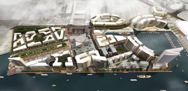
Source: TQ Website
This new place called the Titanic Quarter takes inspiration from the industrial heritage of the former Harland and Wolff site. The new Quarter is described as a “high profile European waterfront development” by the promoters (TQ Website). This £7bn development project comprises a museum (the Titanic Signature), which is being boasted as an “iconic,” even “titanic” landmark and stands as the largest ever tourism project in Belfast.
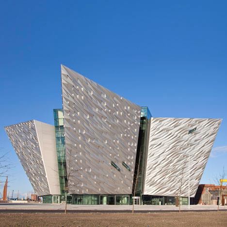
Source: TQ Website
This impressive piece of architecture is home to an exhibition on the Titanic experience where the visitor can explore the wreck, a Titanic-themed banqueting restaurant and a facility for exhibitions, performances and conferences. Culture and urban studies specialist Malcolm Miles identified the elements which are fundamental to designate a culturally-led urban regeneration, one of which is “a flagship cultural institution in a post-industrial zone, often a waterfront site” (Miles 893). The new Quarter fits the description. The cultural element is further developed by the promoters by making references to the industrial heritage of the site, as shown by the 19th century photographs that were selected to provide a sense of identity.
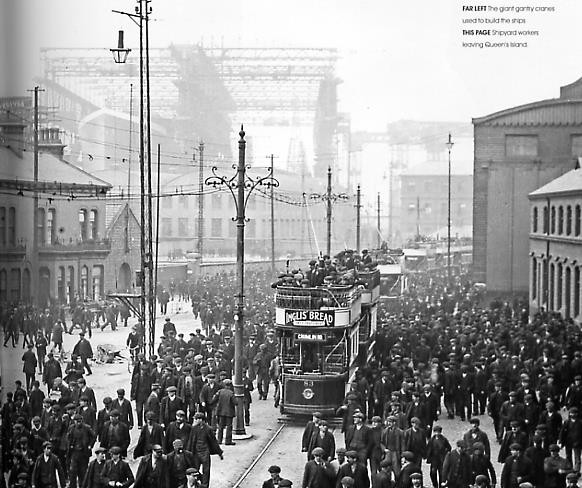
Source: TQ, 2007
This photograph recalls the then vibrant industrial site and conveys a feeling of dynamism as the place is bustling with activity. Planners seek to retrieve a sense of pride from ‘some’ famed past. The references to that past also serve as a basis for the creation of what Marc Augé calls a ‘place’ with a strong link to its industrial past (Augé 1995) thus giving spatial legitimacy to the new Quarter. The cultural message is further developed by one of the Signature architects, Eric Kuhne, who claims that the building is a “maritime” metaphor: “its four projecting segments are instantly evocative of ships prows ploughing their way through the North Atlantic swell. Almost the entire facade will be clad in faceted, three-dimensional plates in a pattern recalling of the construction methods of the great ocean liners” (Kuhne).
The cultural discourse that is created and conveyed here means that the new place is safe and neutral as it enhances universal symbols and completely annihilates local, parochial attachments or histories. This new place also tells a conventional, consensual narrative about hope and bright futures, as shown by the brochure: “Titanic Quarter will build on the past to create a new era for the city” (Titanic Quarter 5). This further corroborates the cosmopolitan character that is attached to the place.
The RISE sculpture
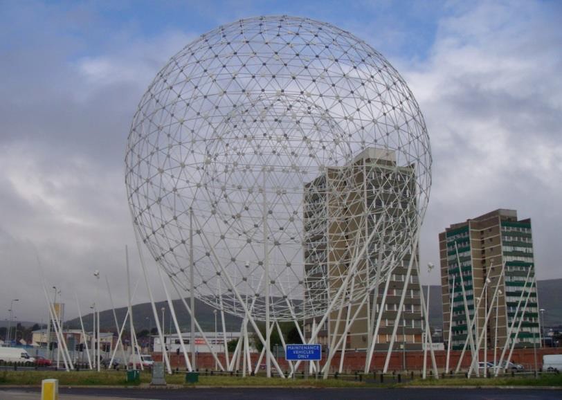
Another example is the RISE sculpture. It was designed by artist Wolfgang Buttress and was inaugurated in September 2011 in Belfast. It is located on one of the busiest roundabouts in Belfast called the Broadway Junction.
Source: Belfast City Council, 2012
The RISE piece of art goes with a message enhancing harmony and promising a bright future. According to the Nottingham artist who designed the sculpture, RISE is in the shape of two globes and is lit up at night to symbolise the rising of the sun (BBC News, 2011).
Source: Photograph taken by author (April 2012)
Buttress explains: “Before there were people on this spot, there were reeds and marsh and I wanted to make a connection to the land, and something universal” (UTV News, 2011). The artist thus adds meaning to the piece of art and creates a connection with the spot where it stands, by linking it to Belfast’s past (“before there were people”) and by referring to original natural elements such as reeds and marsh. He focuses on universal values. Interestingly, so do the Belfast City Council (BCC) in their 2012 leaflet, where they claim that RISE “symbolises a new era for Belfast and hope for the city’s future” (BCC, 2012). The lack of reference to recent history, be it related to the Troubles or to the division between antagonistic communities, and the importance laid on universal values and symbols–typically exemplified by the rising of the sun-point to the cosmopolitan character that has been attached to the sculpture.
Among urban and peace studies specialists, some academics believe that urban development, and particularly culturally-led regeneration with a cosmopolitan character, may contribute to reinforcing peace building efforts. One of them, Scott Bollens, believes that urban development may lead away from violence, as in the case of Bilbao in the Basque region. He claims that: “The Guggenheim and other cultural improvements have moved the region towards a more cosmopolitan character with a closer relationship and openness to contemporary culture, a quality conducive to advancing a moderate and non-violent Basque identity agenda” (Bollens 87). The assumption is that identity disputes become incongruous in places that have been renewed and that now represent ‘modernism,’ as opposed to ‘old’ nationalist discourses and cultures. It is believed that the focus on cosmopolitan values may render the causes of the conflict obsolete, hence the importance of cities, where cosmopolitan cultures are likely to develop, and of architecture which conveys an ideology of universalism (see Jones, 2011).
However, I contend that other factors of spatial fragmentation have been disregarded. First, such new cosmopolitan places may also sharpen social, economic and identity related contrasts by creating hot spots in the city, which are desirable areas where everybody wants to live. These further marginalise the cold spots in some wards, which are unattractive and accumulate factors of social exclusion. Researchers in urban planning in Belfast have stressed recently that new separation lines were in fact created by recent regeneration projects separating social classes even more. It has been noted that the city centre has undergone a phenomenon of gentrification.5 The “cultural improvements” derived from urban regeneration may give rise to unforeseen tensions as the new places may become gentrified and thus widen socially marked discrepancies.6 Big-scale renewal projects in general may also be perceived as serving the interests of capitalist drivers, thus giving rise to tensions between defendants of private and public interests.
In parallel, the road infrastructure – an aspect of the urban fabric which has been neglected – has to be considered as a severing factor. For instance, when one draws attention to the level of ‘sharedness’ and access of the new places mentioned in this study, what stands out is the lack of understanding of how connectivity should be promoted. The barriers and obstacles effectively hindering easy movement and connection are still numerous even in the new places. One among many is the road infrastructure, which effectively cuts off access to the new places.
Assessing the Level of Connectivity
I will now assess the level of connectivity of the new places by examining how accessible they are for both local and international visitors. The sculpture RISE is located on one of the busiest roundabouts of Belfast on the Westlink.
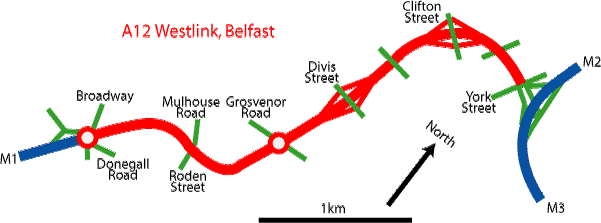
Source: Johnston’s Website
The Westlink connects the M1 to the M2 and M3 by skirting round the west side of Belfast city centre. When the A12 Westlink opened in 1981-83, traffic was diverted from the city centre to the Westlink, but it now clogs up the Westlink particularly at the many junctions which now have become major bottlenecks. Improvement schemes were introduced in 2002 and 2006 widening the Westlink to three lanes first and then building underpasses and slipways. This is when the roundabout was rebuilt and led to the creation of this sculpture. In other words, the cultural element was brought in into a wider road development project.
The visitor wishing to see the sculpture will need to walk through numerous pedestrian crossings. Once there, the visitor is surrounded by a constant flow of cars (more than 65,000 cars daily in 2006 according to Wesley Johnston’s website7). The Belfast Junction is typically what could be called a non-place (Augé, 1995) where people are in transit–either travelling on the M1/Westlink junction or walking across the roundabout. Most of the adjoining areas are access roads, commercial premises or empty plots of land. All such spaces only offer the possibility for people to be passing on them and barely allow longer activities such as visiting, working or lingering away.
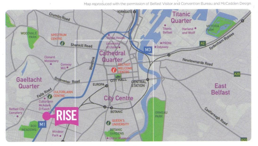
However, it must be noted that the RISE piece of art is oddly located outside the conventional comfort zone of the city centre, framed in white in the map issued by the BCC (Fig 4). Most culturally-led renewal projects devised by statutory bodies have been developed in the city centre area.8 So the unusual location of the sculpture outside the city centre area tends to indicate that some of the invisible barriers separating the city centre from the wards are gradually falling. Moreover, the sculpture sits in the middle of two antagonistic areas–the republican Falls (Beechmount, Falls, Falls Park wards) and the loyalist Village (Blackstaff ward). The Broadway Junction–a formerly lush roundabout–and the busy M1/Westlink both stood as a ‘natural’ separation line9 between the two communities. The creation of a piece of art in a place accessible to all–as it is now used as a footpath–tends to imply that community relations have improved in the area and that former lines of separation may now be transformed into places offering more connectivity, all the more so as the piece of art has not become a focal point for trouble. So the new place does offer more connectivity. However, this intention was not part of the original plan where there is no mention of a thought-out strategy aiming to create connection places (BCC 2005 and 2008). Therefore, although this happened as an outcome, it was not part of the original strategy.
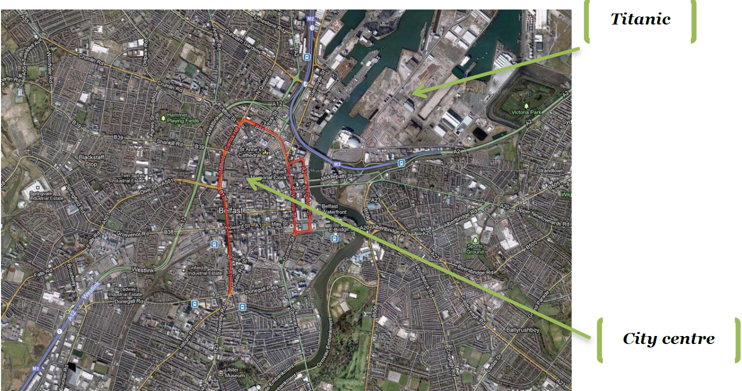
Concerning the Titanic Quarter, getting there is a hazardous journey as the Quarter is cut off from the city centre by two roads dominated by large scale traffic: the M3 motorway and the Inner ring road.
Source: Google map
Moreover, local communities in North Belfast and East Belfast are also severed from the new place as, by both bus and walking, access is lengthy and convoluted.
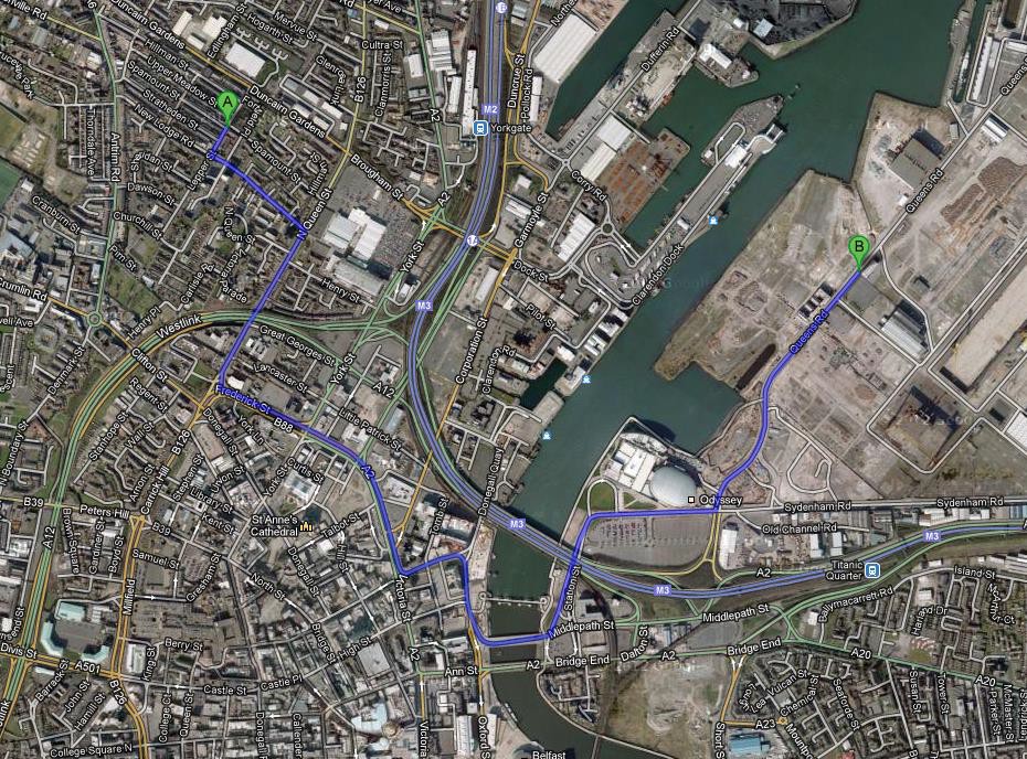
Source: Google maps
As shown by the map, there are no river crossings from the North to the TQ. Moreover, the visitor from the North will have to walk along several busy roads (ring roads) and cross the Westlink and the M3. In addition to poor quality environment along such roads, locals may not benefit from emerging employment opportunities in the TQ, thus aggravating debilitating factors.
Until the late 2000s, roads in and around Belfast were systematically developed to the extent that the city centre area is now bounded by a series of roads of a significant scale (either motorways or dual carriageways). These roads have severed the neighbourhoods from the centre and have also impeded connections between them. Such roads also limit the potential of the new places which become somehow spaced out from the rest of the city. Such disconnected places as the Titanic Quarter may increase the distinction known in other UK cities between hot spots, which are desirable areas where everybody wants to live, and cold spots, which are unattractive and accumulate factors of social exclusion. Researchers in urban planning in Belfast have recently stressed that new separation lines were in fact created by recent regeneration projects, separating social classes even more. It has been noted that the city centre has undergone a phenomenon of gentrification (Murtagh, 2011). In 2008 already Murtagh described a ‘twin speed city’ (Murtagh 2008: 4).
The RISE sculpture, however, does manage to create more connectivity between the two antagonistic areas, as well as between the wards and the city centre. But its location on a roundabout acts as a barrier to easy access and sheds light on the double, clashing objective of developing roads and developing connectivity. This hints at a strategic weakness. Many questions are left unanswered by urban development strategies in Belfast: What can be done to tackle multiple factors of division (some of which were recently aggravated by urban regeneration projects in the 2000s)? What alternative forms of urban regeneration could take all this into account? What could be a more ‘coherent’ urban environment? What is lacking in Belfast is a more coherent strategy and a more complex analysis of spatial disconnection taking multiple factors into account. There are other complexities that need to be unraveled such as fragmented decision-making process (Etchart, 2013).
Interestingly, systematic road development is currently being superseded by alternative plans enhancing better streets, although the focus is only on the city centre. The Department for Regional Development’s masterplan to improve the city’s transport network (DRD, 2011) seeks to reduce traffic levels and encourage greater walking, cycling and public transport use in the city centre area. In the same vein, the 2004 Belfast Metropolitan Transport Plan issued by the Department for Regional Development stressed the need for “calmer” streets. Nevertheless, the severance impact of the road infrastructure on the wards was disregarded.
The study of new places in Belfast has shown that spatial divisions not only developed as a result of Troubles-related violence and intimidation, but that it was also reinforced by policies such as road development policies, albeit indirectly. This shows that a more comprehensive urban development strategy is now necessary, taking into account multiple severance factors in Belfast. The context in which spatial divisions are examined must be broader and encompass such issues as road development and collaborative decision-making. To start from ruins would probably be an easier venture, but the very process of re-stitching the parts of Belfast could represent an interesting, concrete project able to federate its inhabitants around specific aspects of their urban environment.
Notes
- 1Plans aiming at improving the image of the city have existed since the late 1970s, as shown by a document issued by the Northern Ireland Information Service in 1978, entitled Nine Point Package to Spell the Rebirth of Belfast (see Neill 2010: 307-8).
- 2The proportion of catholic/nationalist and protestant/unionist population varies in each ward. A map was drawn following the 1991 census, giving a general idea of how communities were distributed in each ward (see <http://cain.ulst.ac.uk/images/maps/belfast_religion.gif> accessed May 2013).
- 3A power-sharing Assembly was formed in May 2007 and the main paramilitary groups decommissioned successfully in 2005 and 2009-10. Despite these achievements, peace remains fragile as there have been continued sectarian disturbances. Dissident paramilitary groups have also carried several attacks.
- 4Creating ‘shared space’ emerged as a policy objective in the 2000s as a response to the social fragmentation. However, researchers have noted that this notion remains vague. See for instance Komarova’s work (Komarova 2008).
- 5B. Murtagh, Desegregation and Place Restructuring in the New Belfast Urban Studies May 2011 48: 1119-1135.
- 6See Murtagh’s description of Belfast as a “twin speed city” (Murtagh, 2008).
- 7July 2013 <http://www.wesleyjohnston.com/roads/m1.html#trafficdata>
- 8The reasons for this are varied, but mainly, development and regeneration policies have tended to focus on the city centre given that invisible barriers have separated it from its peripheral neighbourhoods fragmented into nationalist and unionist areas. Possibly then, locating a new piece of art in the ‘neutral’ city centre has been an easier venture, as opposed to doing it in areas where place marking practices are still vividly used to enhance one’s identity.
- 9The Broadway Junction area is an interface area separating two antagonistic communities (catholic/nationalist and protestant/unionist).
Bibliography
Primary sources
- Belfast City Council. Final Artists Pack. Belfast: Belfast City Council, 2005.
- Belfast City Council. Broadway Final Artists Pack. Belfast: Belfast City Council, 2008.
- Belfast City Council Tourism, Culture and Arts Unit. RISE leaflet. Belfast: Belfast City Council, 2012.
- Better Public Buildings Group. Better Public Buildings. A Proud Legacy for the Future. London: Department for Culture, Media and Sport, 2000.
- Department of Culture, Arts and Leisure Northern Ireland. Architecture and the Built Environment for Northern Ireland. Belfast: Department of Culture, Arts and Leisure, 2006.
- Department for Regional Development. Belfast Metropolitan Transport Plan. Belfast: DRD, 2004.
- Transport Masterplan for Belfast city centre. Belfast: DRD, 2011.
- Kuhne, Eric. January 2013. <http://www.civicarts.com/titanic-signature-project.php>
- Northern Ireland Information Service. Nine Point Package to Spell the Rebirth of Belfast. Belfast: The Northern Ireland Information Service, 1978.
- Office of the First Minister and Deputy First Minister. A Shared Future. Policy and Strategic Framework for Good Relations in Northern Ireland. Belfast: OFMDFM, 2005.
- Roads Services. M1/Westlink Improvements Public Information Leaflet. Belfast: Roads Services, 2006.
- Stakeholder. “Titanic Quarter scoops top award for regeneration.” January 2013. <http://www.stakeholdergroup.com/news/titanic-quarter-scoops-top-award-for-regeneration, 2011>
- Titanic Quarter. Titanic Quarter, Regenerating Belfast. London: 3Fox International, 2007.
- TQ Website. January 2013. <http://www.titanic-quarter.com>
- UTV News. “Rise sculpture unveiled in Belfast.” January 2013. <http://www.u.tv/news/Rise-sculpture-unveiled-in-Belfast/f1d95092-04ba-4f5c-960c-309d302af2ce, 2011>
Secondary sources
- Augé, Marc. Non-places: Introduction to an Anthropology of Supermodernity. London/New York: Verso, 1995.
- Bollens, Scott. City and Soul in Divided Societies. Oxford/New York: Routledge, 2012.
- Darby, John. Intimidation in Housing. Belfast: The Northern Ireland Community Relations Commission, 1974.
- Etchart, Joana. “The Titanic Quarter in Belfast: Building a New Place in a Divided City.” Nordic Irish Studies Journal 7 (2008): 31-40
- Etchart, Joana. “Belfast Renewed: A Sign of Change?” C. Rees (ed). Changes in Contemporary Ireland. Newcastle upon Tyne: CSP, 2013: 32-50
- Forum for Alternative Belfast (FAB). Shared Space 2011. Belfast: Forum for Alternative Belfast and Belfast Conflict Resolution Consortium, 2011.
- Gaffikin, Frank and Morrissey, Mike. Planning in Divided Cities: Collaborative Shaping of Contested Space. Oxford: Blackwell Publishing Ltd, 2011.
- Johnston, Wesley. Website on Northern Ireland roads. January 2013. <http://www.wesleyjohnston.com/roads/busiestroads.html>
- Jones, Paul. The Sociology of Architecture. Liverpool: The University of Liverpool Press, 2011.
- Komarova, Milena. “Shared Space in Belfast and the Limits of A Shared Future.” Divided Cities/Contested States Working Paper N°3, 2008. August 2015 <http://www.conflictincities.org/PDFs/WorkingPaper3rev_11.3.10.pdf>
- Komarova, Milena and O’Dowd, Liam. “Regeneration in a Contested City: A Belfast Case Study.” Divided Cities/Contested States Working Paper N°10, 2009. August 2015 <http://www.conflictincities.org/PDFs/WorkingPaper10_14.4.10.pdf>
- Miles, Malcolm. “Interruptions: Testing the Rhetoric of Culturally Led Urban Development.” Urban Studies 42. 5/6 (2005): 889-911
- Murtagh, Brendan. “New Spaces and Old in ‘Post-Conflict’ Belfast.” Divided Cities/Contested States Working Papers n°5, 2008. August 2015 <http://www.conflictincities.org/PDFs/WorkingPaper5_10.9.08.pdf>
- Murtagh, Brendan. “Desegregation and Place Restructuring in the New Belfast.” Urban Studies 48.6 (2011): 1119-1135
- Neill, W.J.V. “Northern Ireland, an Introduction.” Urban Design and the British Urban Renaissance. Ed. John Punter. London: Routledge, 2010. 303-5
- Neill, W.J.V. “Belfast. Rebranding the ‘Renaissance City’: from ‘the Troubles’ to Titanic Quarter.” Urban Design and the British Urban Renaissance. Ed. John Punter. London: Routledge, 2010. 305-21
About the author(s)
Biography: Joana Etchart is a Lecturer in Irish and British History at the Sorbonne Paris 4. Her current research interests are centred on the study of public policies and community initiatives in the field of peacebuilding in Northern Ireland. She also studies urban regeneration projects in Irish and British cities. In her work, regeneration projects such as the Titanic Quarter in Belfast serve as an entry point for analysing the complex relationship between power, culture and identity. She will shortly publish a book on the origins of community relations policies in Northern Ireland (forthcoming with Presses Universitaires de Paris-Sorbonne).